
Make a donation
Gear up for your next adventure:
As an Amazon Associate, this site earns from qualifying purchases at no extra cost to you.
Mölltal topographic map
Click on the map to display elevation.
Make a donation
Gear up for your next adventure:
As an Amazon Associate, this site earns from qualifying purchases at no extra cost to you.
About this map
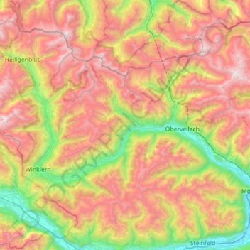
Name: Mölltal topographic map, elevation, terrain.
Location: Mölltal, Bezirk Spittal an der Drau, Carinthia, 9418, Austria (46.83084 12.81596 47.04564 13.37688)
Average elevation: 5,948 ft
Minimum elevation: 1,834 ft
Maximum elevation: 10,876 ft
Make a donation
Gear up for your next adventure:
As an Amazon Associate, this site earns from qualifying purchases at no extra cost to you.
Other topographic maps
Click on a map to view its topography, its elevation and its terrain.
Seebach
Austria > Carinthia > Bezirk Spittal an der Drau > Seeboden am Millstätter See
Average elevation: 2,146 ft
Innerkrems
Austria > Carinthia > Bezirk Spittal an der Drau > Krems in Kärnten
Average elevation: 5,942 ft
Kleindombra
Austria > Carinthia > Bezirk Spittal an der Drau > Millstatt am See > Obermillstatt > Kleindombra
Average elevation: 2,671 ft
Make a donation
Gear up for your next adventure:
As an Amazon Associate, this site earns from qualifying purchases at no extra cost to you.
Schmelzhütten
Austria > Carinthia > Bezirk Spittal an der Drau > Flattachberg > Schmelzhütten
Average elevation: 3,668 ft