
Make a donation
Gear up for your next adventure:
As an Amazon Associate, this site earns from qualifying purchases at no extra cost to you.
Kiambere topographic map
Click on the map to display elevation.
Make a donation
Gear up for your next adventure:
As an Amazon Associate, this site earns from qualifying purchases at no extra cost to you.
About this map
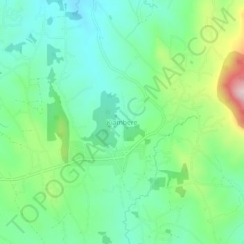
Name: Kiambere topographic map, elevation, terrain.
Location: Kiambere, Embu, East Kenya, Kenya (-0.72000 37.76330 -0.68000 37.80330)
Average elevation: 3,307 ft
Minimum elevation: 2,956 ft
Maximum elevation: 4,160 ft
Make a donation
Gear up for your next adventure:
As an Amazon Associate, this site earns from qualifying purchases at no extra cost to you.
Other topographic maps
Click on a map to view its topography, its elevation and its terrain.
Embu
The Municipality of Embu has an elevation of 1,350 metres (4,429 ft), and is located on the foothills of Mount Kenya. It was the provincial headquarters of the defunct Eastern province, and is currently the Embu County Headquarters, hosting major public offices and institutions, including Embu Provincial…
Average elevation: 4,436 ft