
Thank you for supporting this site ❤️
Make a donation
Make a donation
Gear up for your next adventure:
As an Amazon Associate, this site earns from qualifying purchases at no extra cost to you.
宗嘎镇 topographic map
Click on the map to display elevation.
Thank you for supporting this site ❤️
Make a donation
Make a donation
Gear up for your next adventure:
As an Amazon Associate, this site earns from qualifying purchases at no extra cost to you.
About this map
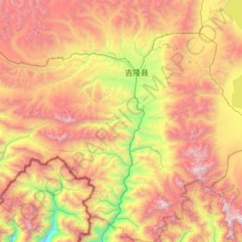
Name: 宗嘎镇 topographic map, elevation, terrain.
Location: 宗嘎镇, Gyirong County, Shigatse, Tibet, China (28.51711 84.95037 28.99847 85.43652)
Average elevation: 16,332 ft
Minimum elevation: 10,623 ft
Maximum elevation: 22,477 ft
Thank you for supporting this site ❤️
Make a donation
Make a donation
Gear up for your next adventure:
As an Amazon Associate, this site earns from qualifying purchases at no extra cost to you.