Geolocate

Remsen topographic map

Click on the map to display elevation.

About this map

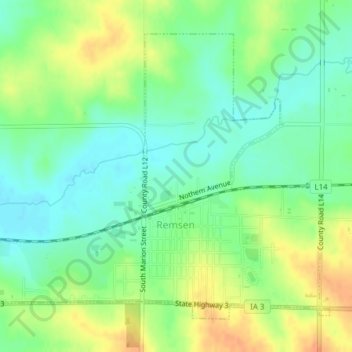
Name: Remsen topographic map, elevation, terrain.

Location: Remsen, Plymouth County, Iowa, United States (42.80718 -95.99506 42.83008 -95.95655)

Average elevation: 1,342 ft

Minimum elevation: 1,286 ft

Maximum elevation: 1,421 ft

Plymouth County trails, hiking, mountain biking, running and outdoor activities

Gear up for your next adventure:

🧢Outdoor Hiking Hat - Sun protection hat for outdoor explorers
🗺️Topographic Maps - Detailed topo maps for hiking, exploring and outdoor navigation
📡Handheld GPS Device - Reliable handheld GPS for outdoor navigation
🧺Microfiber Travel Towels - Compact and fast-drying towels for trail use
🌧️Backpack Rain Cover - Keep gear dry in wet weather

As an Amazon Associate, this site earns from qualifying purchases at no extra cost to you.