
Thank you for supporting this site ❤️
Make a donation
Make a donation
Gear up for your next adventure:
As an Amazon Associate, this site earns from qualifying purchases at no extra cost to you.
Arranhadouro topographic map
Click on the map to display elevation.
Thank you for supporting this site ❤️
Make a donation
Make a donation
Gear up for your next adventure:
As an Amazon Associate, this site earns from qualifying purchases at no extra cost to you.
About this map
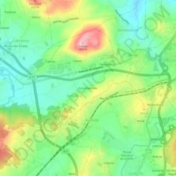
Name: Arranhadouro topographic map, elevation, terrain.
Location: Arranhadouro, Sequeira, Braga, 4705-629, Portugal (41.50866 -8.48793 41.54866 -8.44793)
Average elevation: 502 ft
Minimum elevation: 236 ft
Maximum elevation: 961 ft
Thank you for supporting this site ❤️
Make a donation
Make a donation
Gear up for your next adventure:
As an Amazon Associate, this site earns from qualifying purchases at no extra cost to you.