
Lake Pukaki topographic map
Interactive map
Click on the map to display elevation.
About this map
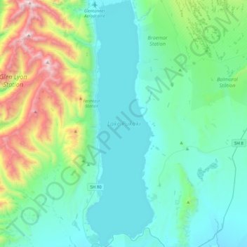
Name: Lake Pukaki topographic map, elevation, terrain.
Location: Lake Pukaki, Mackenzie District, Canterbury, New Zealand (-44.19050 170.11500 -43.90489 170.22307)
Average elevation: 2,907 ft
Minimum elevation: 1,660 ft
Maximum elevation: 8,179 ft
Other topographic maps
Click on a map to view its topography, its elevation and its terrain.
Mount Blackburn
New Zealand > Canterbury > Mackenzie District
Mount Blackburn, Mackenzie District, Canterbury, New Zealand
Average elevation: 5,361 ft
Twizel
New Zealand > Canterbury > Mackenzie District
Twizel, Mackenzie District, Canterbury, 7901, New Zealand
Average elevation: 1,549 ft
Burkes Pass
New Zealand > Canterbury > Mackenzie District > Burkes Pass
Burkes Pass, Mackenzie District, Canterbury, New Zealand
Average elevation: 2,041 ft
Mount Cook
New Zealand > Canterbury > Mackenzie District
Mount Cook, Mackenzie District, Canterbury, New Zealand
Average elevation: 9,580 ft
Lake Benmore
New Zealand > Canterbury > Mackenzie District
Lake Benmore, Mackenzie District, Canterbury, New Zealand
Average elevation: 2,444 ft
Lake Tekapo
New Zealand > Canterbury > Mackenzie District
Lake Tekapo, Mackenzie District, Canterbury, New Zealand
Average elevation: 3,363 ft
Fairlie
New Zealand > Canterbury > Mackenzie District
Fairlie, Mackenzie District, Canterbury, 7925, New Zealand
Average elevation: 1,040 ft
Tasman Lake
New Zealand > Canterbury > Mackenzie District
Tasman Lake, Mackenzie District, Canterbury, New Zealand
Average elevation: 3,478 ft