Geolocate

Arbutus topographic map

Click on the map to display elevation.

About this map

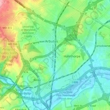
Name: Arbutus topographic map, elevation, terrain.

Location: Arbutus, Baltimore County, Maryland, United States (39.21275 -76.72309 39.26809 -76.65986)

Average elevation: 138 ft

Minimum elevation: 7 ft

Maximum elevation: 466 ft

Baltimore County trails, hiking, mountain biking, running and outdoor activities

Gear up for your next adventure:

🔦Powerful Headlamps - Ultra-bright hands-free lighting for night navigation
⛑️Personal Locator Beacon - Safety beacon for emergencies
📱Heavy-Duty Phone Cases - Drop-proof and waterproof protection for outdoor navigation
🔭Compact Binoculars - HD vision for scouting terrain and identifying distant landmarks
🌡️Handheld Weather Meters - Measure wind, temp, and pressure for safe mountain travel

As an Amazon Associate, this site earns from qualifying purchases at no extra cost to you.