
Make a donation
Gear up for your next adventure:
As an Amazon Associate, this site earns from qualifying purchases at no extra cost to you.
Masholder topographic map
Click on the map to display elevation.
Make a donation
Gear up for your next adventure:
As an Amazon Associate, this site earns from qualifying purchases at no extra cost to you.
Masholder
Aufgrund der Nähe zu Bitburg gibt es in Masholder nur noch wenige Dienstleistungsunternehmen. Im Gewerbegebiet Masholderer Höhe haben sich mehrere Unternehmen angesiedelt. Ein wichtiger Arbeitgeber ist unter anderem das Deutsche Rote Kreuz mit einer Rettungswache. Des Weiteren sind dort eine Möbelschreinerei, eine Kfz-Werkstatt, ein Kfz-Lackiererei sowie eine Tiefbaufirma zu finden.
Make a donation
Gear up for your next adventure:
As an Amazon Associate, this site earns from qualifying purchases at no extra cost to you.
About this map
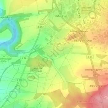
Name: Masholder topographic map, elevation, terrain.
Average elevation: 1,043 ft
Minimum elevation: 820 ft
Maximum elevation: 1,270 ft
Make a donation
Gear up for your next adventure:
As an Amazon Associate, this site earns from qualifying purchases at no extra cost to you.