
Yeysk topographic map
Interactive map
Click on the map to display elevation.
About this map
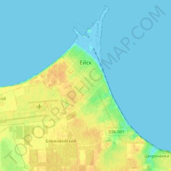
Name: Yeysk topographic map, elevation, terrain.
Average elevation: 23 ft
Minimum elevation: -16 ft
Maximum elevation: 82 ft
Other topographic maps
Click on a map to view its topography, its elevation and its terrain.
Komsomolets
Russia > Krasnodar Krai > Yeysky District
Komsomolets, Красноармейское сельское поселение, Yeysky District, Krasnodar Krai, Southern Federal District, 353670, Russia
Average elevation: 85 ft