Geolocate

Pentagna topographic map

Click on the map to display elevation.

About this map

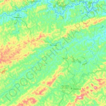
Name: Pentagna topographic map, elevation, terrain.

Location: Pentagna, Valença, Região Geográfica Imediata de Valença, Região Geográfica Intermediária de Volta Redonda-Barra Mansa, Rio de Janeiro, Região Sudeste, Brasil (-22.27812 -43.88811 -22.07079 -43.65909)

Average elevation: 1,900 ft

Minimum elevation: 1,319 ft

Maximum elevation: 3,314 ft

Other topographic maps

Click on a map to view its topography, its elevation and its terrain.

Conservatória RJ

Brasil > Rio de Janeiro > Valença

Average elevation: 1,916 ft

Açude da Concórdia

Brasil > Rio de Janeiro > Valença

Average elevation: 2,687 ft

Pentagna

Brasil > Rio de Janeiro > Valença > Pentagna

Average elevation: 1,801 ft

Gear up for your next adventure:

🪶Camping Sleeping Pad - Comfortable sleeping pad for backpacking
🧭GPS Watch Accessories - Bands and chargers for GPS watches
🔥Fast-Boil Camping Stoves - Efficient cooking systems for quick trail meals
📌Outdoor GPS Map App - Apps and devices for digital topographic navigation
📚USA Hiking Guide Books - Top trail guides and map books

As an Amazon Associate, this site earns from qualifying purchases at no extra cost to you.