Geolocate

Torrecilla Alta topographic map

Click on the map to display elevation.

About this map

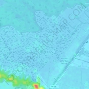
Name: Torrecilla Alta topographic map, elevation, terrain.

Location: Torrecilla Alta, Loíza, Puerto Rico, United States (18.40107 -65.93089 18.43643 -65.89565)

Average elevation: 10 ft

Minimum elevation: -13 ft

Maximum elevation: 213 ft

Puerto Rico trails, hiking, mountain biking, running and outdoor activities

Gear up for your next adventure:

👓Polarized Sunglasses - Outdoor sunglasses for glare reduction
Backpacking Tent - Lightweight and durable tent for multi‑day hikes
🌎3D Topographic Globes - Raised relief globes for a tactile understanding of geography
🛰️Handheld GPS Units - Professional satellite navigators for precise backcountry mapping
🧭Pro Hiking Compasses - High-accuracy liquid-filled compasses for topographic orientation

As an Amazon Associate, this site earns from qualifying purchases at no extra cost to you.