Geolocate
👉 Easily get elevation data in JSON, GeoTIFF and KML formats using Elevation API
Thank you for supporting this site ❤️
Make a donation

Pebble Pointe topographic map

Click on the map to display elevation.

About this map

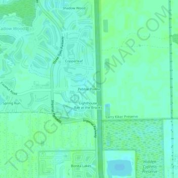
Name: Pebble Pointe topographic map, elevation, terrain.

Location: Pebble Pointe, Lee County, Florida, 33928, United States (26.37630 -81.79517 26.41630 -81.75517)

Average elevation: 23 ft

Minimum elevation: 7 ft

Maximum elevation: 36 ft

Lee County trails, hiking, mountain biking, running and outdoor activities

Gear up for your next adventure:

🧥Men's Rain Shells - Premium waterproof and breathable jackets for mountain weather
🌡️Handheld Weather Meters - Measure wind, temp, and pressure for safe mountain travel
Backpacking Tents - Weight-optimized shelters for multi-day topographic surveys
🕶️GPS Smartphone Mount - Secure mount for phone navigation
🧷Carabiner Set - Durable clips for gear attachment

As an Amazon Associate, this site earns from qualifying purchases at no extra cost to you.