
Make a donation
Gear up for your next adventure:
As an Amazon Associate, this site earns from qualifying purchases at no extra cost to you.
Osbourn topographic map
Click on the map to display elevation.
Make a donation
Gear up for your next adventure:
As an Amazon Associate, this site earns from qualifying purchases at no extra cost to you.
About this map
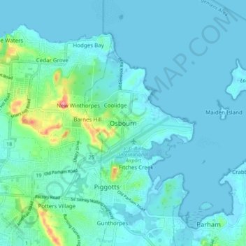
Name: Osbourn topographic map, elevation, terrain.
Location: Osbourn, Saint George, Antigua, Antigua and Barbuda (17.10142 -61.83736 17.18142 -61.75736)
Average elevation: 52 ft
Minimum elevation: -7 ft
Maximum elevation: 427 ft
Make a donation
Gear up for your next adventure:
As an Amazon Associate, this site earns from qualifying purchases at no extra cost to you.
Other topographic maps
Click on a map to view its topography, its elevation and its terrain.
Antigua
Located in the Leeward Islands, Antigua has an area of 281 km2 (108 sq mi) with 87 km (54 mi) of coastline. The island is reputed to possess 365 beaches, one for every day of the year. The highest elevation on the island is 402 m (1,319 ft).
Average elevation: 69 ft