
Make a donation
Gear up for your next adventure:
As an Amazon Associate, this site earns from qualifying purchases at no extra cost to you.
Elverdinge topographic map
Click on the map to display elevation.
Make a donation
Gear up for your next adventure:
As an Amazon Associate, this site earns from qualifying purchases at no extra cost to you.
Elverdinge
Elverdinge ligt in Zandlemig Vlaanderen op een hoogte van ongeveer 14 meter in het dal van de Grote Kemmelbeek, welke in noordelijke richting stroomt. Het belangrijkste bosgebied, ten zuidwesten van de dorpskom, wordt gevormd door de Galgebossen. Daarnaast is er het park van het Kasteel van Elverdinge.
Make a donation
Gear up for your next adventure:
As an Amazon Associate, this site earns from qualifying purchases at no extra cost to you.
About this map
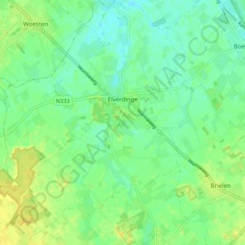
Name: Elverdinge topographic map, elevation, terrain.
Location: Elverdinge, Ieper, West-Vlaanderen, Vlaanderen, 8906, België (50.85736 2.76906 50.90503 2.83931)
Average elevation: 46 ft
Minimum elevation: 16 ft
Maximum elevation: 85 ft
Make a donation
Gear up for your next adventure:
As an Amazon Associate, this site earns from qualifying purchases at no extra cost to you.
Other topographic maps
Click on a map to view its topography, its elevation and its terrain.