Geolocate

Pot topographic map

Click on the map to display elevation.

About this map

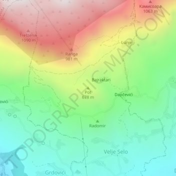
Name: Pot topographic map, elevation, terrain.

Location: Pot, Velje Selo, Bar Municipality, 85356, Montenegro (42.04346 19.19203 42.04356 19.19213)

Average elevation: 1,991 ft

Minimum elevation: 614 ft

Maximum elevation: 4,045 ft

Gear up for your next adventure:

🥘Titanium Cookware - Durable, featherlight pots and pans for backpacking
🧥Men's Rain Shells - Premium waterproof and breathable jackets for mountain weather
🗻Climbing Gear Basics - Essential gear for beginner climbers
📌Outdoor GPS Map App - Apps and devices for digital topographic navigation
🦶Carbon Trekking Poles - Reduce knee impact on steep descents with ultra-light poles

As an Amazon Associate, this site earns from qualifying purchases at no extra cost to you.