Geolocate

Plympton topographic map

Click on the map to display elevation.

About this map
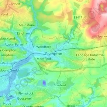
Name: Plympton topographic map, elevation, terrain.

Location: Plympton, Plymouth, England, PL7 4PE, United Kingdom (50.34982 -4.09857 50.42982 -4.01857)

Average elevation: 230 ft

Minimum elevation: -125 ft

Maximum elevation: 784 ft

Other topographic maps

Click on a map to view its topography, its elevation and its terrain.
Plymouth Hoe

United Kingdom > England > Plymouth

Average elevation: 39 ft

Mutley Park

United Kingdom > England > Plymouth

Average elevation: 177 ft

Hooe Lake

United Kingdom > England > Plymouth

Average elevation: 82 ft

Cann Woods

United Kingdom > England > Plymouth

Average elevation: 187 ft

Devonport Park

United Kingdom > England > Plymouth

Average elevation: 49 ft

Central Park

United Kingdom > England > Plymouth > Crownhill

Average elevation: 161 ft

Beaumont Park

United Kingdom > England > Plymouth

Average elevation: 79 ft

Whitleigh Wood

United Kingdom > England > Plymouth > Crownhill

Average elevation: 226 ft

Gear up for your next adventure:

🪶Fire Starter Kit - Reliable fire starter for survival and camping
🥄Camping Utensil Set - Lightweight utensils for outdoor meals
🔭Telescopic Hiking Pole - Adjustable pole for hiking stability
💧Water Filtration Bottles - Safely drink from streams and lakes while exploring
🧭GPS Watch Accessories - Bands and chargers for GPS watches

As an Amazon Associate, this site earns from qualifying purchases at no extra cost to you.