
Make a donation
Gear up for your next adventure:
As an Amazon Associate, this site earns from qualifying purchases at no extra cost to you.
Hixton topographic map
Click on the map to display elevation.
Make a donation
Gear up for your next adventure:
As an Amazon Associate, this site earns from qualifying purchases at no extra cost to you.
About this map
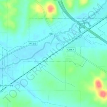
Name: Hixton topographic map, elevation, terrain.
Location: Hixton, Jackson County, Wisconsin, United States (44.37184 -91.03242 44.38974 -90.99519)
Average elevation: 958 ft
Minimum elevation: 909 ft
Maximum elevation: 1,129 ft
Jackson County trails, hiking, mountain biking, running and outdoor activities
Make a donation
Gear up for your next adventure:
As an Amazon Associate, this site earns from qualifying purchases at no extra cost to you.
Other topographic maps
Click on a map to view its topography, its elevation and its terrain.
Black River Falls
United States > Wisconsin > Jackson County > Black River Falls
Average elevation: 866 ft