
Make a donation
Gear up for your next adventure:
As an Amazon Associate, this site earns from qualifying purchases at no extra cost to you.
Dolní Morava topographic map
Click on the map to display elevation.
Make a donation
Gear up for your next adventure:
As an Amazon Associate, this site earns from qualifying purchases at no extra cost to you.
Dolní Morava
Sky Bridge 721, the longest suspension footbridge in the world, is located here. The 721 metres (2,365 ft) long bridge, located at an altitude of 1,110 m (3,640 ft) above sea level, was opened to the public in May 2022.
Make a donation
Gear up for your next adventure:
As an Amazon Associate, this site earns from qualifying purchases at no extra cost to you.
About this map
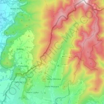
Name: Dolní Morava topographic map, elevation, terrain.
Average elevation: 2,756 ft
Minimum elevation: 1,529 ft
Maximum elevation: 4,672 ft
Make a donation
Gear up for your next adventure:
As an Amazon Associate, this site earns from qualifying purchases at no extra cost to you.
Other topographic maps
Click on a map to view its topography, its elevation and its terrain.