Geolocate

Oberreute topographic map

Click on the map to display elevation.

About this map

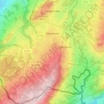
Name: Oberreute topographic map, elevation, terrain.

Location: Oberreute, Stiefenhofen (VGem), Landkreis Lindau, Bavaria, 88179, Germany (47.52964 9.90853 47.57956 9.96962)

Average elevation: 2,723 ft

Minimum elevation: 1,969 ft

Maximum elevation: 3,415 ft

Other topographic maps

Click on a map to view its topography, its elevation and its terrain.

Oberreutin

Germany > Bavaria > Landkreis Lindau > Lindau (Bodensee)

Average elevation: 1,421 ft

Staudach

Germany > Bavaria > Landkreis Lindau

Average elevation: 2,005 ft

Hagers

Germany > Bavaria > Landkreis Lindau > Hergensweiler

Average elevation: 1,706 ft

Buflingsried

Germany > Bavaria > Landkreis Lindau > Scheidegg

Average elevation: 2,490 ft

Holzleute

Germany > Bavaria > Landkreis Lindau > Stiefenhofen

Average elevation: 2,651 ft

Gear up for your next adventure:

🛶Inflatable Kayak - Portable kayak for rivers, lakes, and expeditions
🌡️Handheld Weather Meters - Measure wind, temp, and pressure for safe mountain travel
👓Polarized Sunglasses - Outdoor sunglasses for glare reduction
🔦Compact Flashlight - Reliable flashlight for emergencies
🧭Orienteering Set - Complete compass and map reading kit

As an Amazon Associate, this site earns from qualifying purchases at no extra cost to you.