Geolocate

Rizal topographic map

Click on the map to display elevation.

About this map

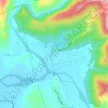
Name: Rizal topographic map, elevation, terrain.

Location: Rizal, Pugo, La Union, Ilocos Region, 2508, Philippines (16.34526 120.41912 16.38526 120.45912)

Average elevation: 341 ft

Minimum elevation: 66 ft

Maximum elevation: 1,253 ft

Gear up for your next adventure:

🪶Wildlife Field Guides - Learn animal tracking and species ID
🪶Survival Guide Book - Expert advice for emergency preparedness
🔌USB Car Charger - Car charger for on‑the‑go power needs
🛌Ultralight Sleeping Bags - Compact down bags for cold nights in the wilderness
🪓Survival Multi‑Tool - Versatile tool for camp and trail tasks

As an Amazon Associate, this site earns from qualifying purchases at no extra cost to you.