Geolocate

Carmel topographic map

Click on the map to display elevation.

About this map

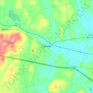
Name: Carmel topographic map, elevation, terrain.

Location: Carmel, Penobscot County, Maine, 04419, United States (44.74576 -69.10269 44.84835 -68.95884)

Average elevation: 249 ft

Minimum elevation: 115 ft

Maximum elevation: 617 ft

Other topographic maps

Click on a map to view its topography, its elevation and its terrain.

Bangor Hill

United States > Maine > Penobscot County > Orono

Average elevation: 203 ft

Hudson Hill

United States > Maine > Penobscot County > Hudson

Average elevation: 253 ft

Blackcap

United States > Maine > Penobscot County > Eddington

Average elevation: 571 ft

Sugar Island

United States > Maine > Penobscot County > Greenbush

Average elevation: 135 ft

Tiger Rips

United States > Maine > Penobscot County

Average elevation: 741 ft

State Island

United States > Maine > Penobscot County

Average elevation: 482 ft

Lincoln

United States > Maine > Penobscot County > Lincoln

Average elevation: 272 ft

Gear up for your next adventure:

📖Nature Tracking Books - Learn to track wildlife and terrain
Backpacking Tents - Weight-optimized shelters for multi-day topographic surveys
🥾Hiking Shoes - Durable and comfortable shoes for trail hiking
🧢Outdoor Hiking Hat - Sun protection hat for outdoor explorers
💧Water Purification System - Clean water on the trail with reliable purifiers

As an Amazon Associate, this site earns from qualifying purchases at no extra cost to you.