
Thank you for supporting this site ❤️
Make a donation
Make a donation
Gear up for your next adventure:
As an Amazon Associate, this site earns from qualifying purchases at no extra cost to you.
Parícuaro topographic map
Click on the map to display elevation.
Thank you for supporting this site ❤️
Make a donation
Make a donation
Gear up for your next adventure:
As an Amazon Associate, this site earns from qualifying purchases at no extra cost to you.
About this map
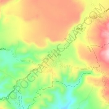
Name: Parícuaro topographic map, elevation, terrain.
Location: Parícuaro, Juárez, Michoacán, Mexico (19.24312 -100.47707 19.28312 -100.43707)
Average elevation: 4,209 ft
Minimum elevation: 3,737 ft
Maximum elevation: 4,656 ft
Thank you for supporting this site ❤️
Make a donation
Make a donation
Gear up for your next adventure:
As an Amazon Associate, this site earns from qualifying purchases at no extra cost to you.