
Belogorye topographic map
Interactive map
Click on the map to display elevation.
About this map
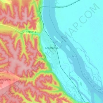
Name: Belogorye topographic map, elevation, terrain.
Average elevation: 584 ft
Minimum elevation: 410 ft
Maximum elevation: 902 ft
Other topographic maps
Click on a map to view its topography, its elevation and its terrain.
Blagoveshchensk
Russia > Amur Oblast > городской округ Благовещенск > Blagoveshchensk
Blagoveshchensk, городской округ Благовещенск, Amur Oblast, Far Eastern Federal District, 675028, Russia
Average elevation: 558 ft
Blagoveshchensk
Russia > Amur Oblast > городской округ Благовещенск
Blagoveshchensk, городской округ Благовещенск, Amur Oblast, Far Eastern Federal District, Russia
Average elevation: 558 ft