Geolocate

Richland topographic map

Click on the map to display elevation.

About this map

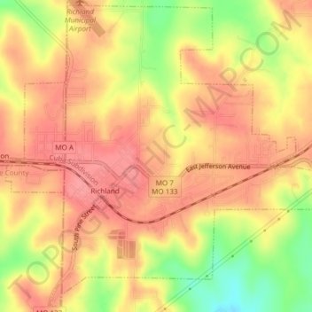
Name: Richland topographic map, elevation, terrain.

Location: Richland, Pulaski County, Missouri, 65556, United States (37.84591 -92.41635 37.87463 -92.37881)

Average elevation: 1,060 ft

Minimum elevation: 889 ft

Maximum elevation: 1,145 ft

Pulaski County trails, hiking, mountain biking, running and outdoor activities

Other topographic maps

Click on a map to view its topography, its elevation and its terrain.

Devils Elbow

United States > Missouri > Pulaski County

Average elevation: 846 ft

Gear up for your next adventure:

🚁Photography Drones - Capture stunning aerial views of landforms and topography
📱Solar Portable Charger - Solar power bank for charging devices off‑grid
Backpacking Tent - Lightweight and durable tent for multi‑day hikes
🪶LED Camping Lantern - Bright lantern for camp lighting
🥾Men's Hiking Boots - Durable, waterproof footwear for rugged terrain and steep inclines

As an Amazon Associate, this site earns from qualifying purchases at no extra cost to you.