Geolocate

Swanson topographic map

Click on the map to display elevation.

About this map

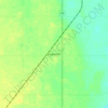
Name: Swanson topographic map, elevation, terrain.

Location: Swanson, Montrose No. 315, Saskatchewan, Canada (51.67306 -107.16274 51.71306 -107.12274)

Average elevation: 1,762 ft

Minimum elevation: 1,729 ft

Maximum elevation: 1,791 ft

Gear up for your next adventure:

Camping Coffee Makers - Enjoy premium coffee at the summit or campsite
💧Water Purification System - Clean water on the trail with reliable purifiers
🦟Ultrasonic Repellers - Create a bug-free zone at your camp or rest stop
📌Outdoor GPS Map App - Apps and devices for digital topographic navigation
🪶LED Camping Lantern - Bright lantern for camp lighting

As an Amazon Associate, this site earns from qualifying purchases at no extra cost to you.