
Lake Charles topographic map
Click on the map to display elevation.
Lake Charles
Lake Charles, located on a level plain about 30 miles (48 km) from the Gulf of Mexico, has an elevation of approximately 13 feet (4.0 m) above sea level, and is located on the banks of the Calcasieu River in southwestern Louisiana. It borders both Lake Charles and Prien Lake. Contraband Bayou, Henderson Bayou, and English Bayou flow through the city. Oak trees and pine trees dot the landscape; the lumber industry was once the main economic engine of the area. The Calcasieu Ship Channel, which allows large ocean-going vessels to sail up from the Gulf, also borders the city.
About this map
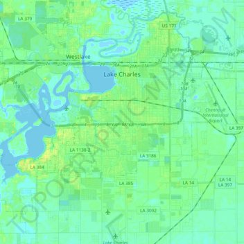
Name: Lake Charles topographic map, elevation, terrain.
Location: Lake Charles, Calcasieu Parish, Louisiana, United States (30.12450 -93.31686 30.27220 -93.12883)
Average elevation: 16 ft
Minimum elevation: -10 ft
Maximum elevation: 59 ft
Calcasieu Parish trails, hiking, mountain biking, running and outdoor activities
Other topographic maps
Click on a map to view its topography, its elevation and its terrain.
Pine Acres Trailer Park
United States > Louisiana > Calcasieu Parish > Lake Charles
Average elevation: 23 ft