
Make a donation
Gear up for your next adventure:
As an Amazon Associate, this site earns from qualifying purchases at no extra cost to you.
Heiligenkirchen topographic map
Click on the map to display elevation.
Make a donation
Gear up for your next adventure:
As an Amazon Associate, this site earns from qualifying purchases at no extra cost to you.
Heiligenkirchen
Zwischen Heiligenkirchen-Mitte und Detmold wurde mit der 1900 in Betrieb genommenen Straßenbahnlinie am Südwesthang des Büchenberges mit Blick auf das Hermannsdenkmal die Villenkolonie Friedrichshöhe errichtet, die bereits vor dem Ersten Weltkrieg mehr Villen als Heiligenkirchen Bauernhöfe aufwies.
Make a donation
Gear up for your next adventure:
As an Amazon Associate, this site earns from qualifying purchases at no extra cost to you.
About this map
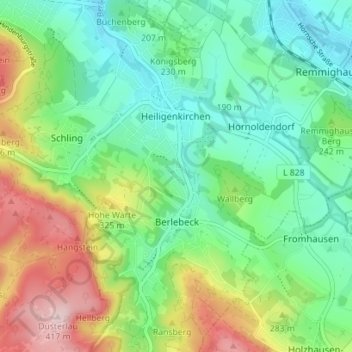
Name: Heiligenkirchen topographic map, elevation, terrain.
Average elevation: 942 ft
Minimum elevation: 476 ft
Maximum elevation: 1,391 ft
Make a donation
Gear up for your next adventure:
As an Amazon Associate, this site earns from qualifying purchases at no extra cost to you.
Other topographic maps
Click on a map to view its topography, its elevation and its terrain.
Make a donation
Gear up for your next adventure:
As an Amazon Associate, this site earns from qualifying purchases at no extra cost to you.
Stemberg
Deutschland > Nordrhein-Westfalen > Kreis Lippe > Detmold > Berlebeck
Average elevation: 873 ft
Lippischer Meierhof
Deutschland > Nordrhein-Westfalen > Kreis Lippe > Detmold
Average elevation: 587 ft
Make a donation
Gear up for your next adventure:
As an Amazon Associate, this site earns from qualifying purchases at no extra cost to you.