
Make a donation
Gear up for your next adventure:
As an Amazon Associate, this site earns from qualifying purchases at no extra cost to you.
Eden topographic map
Click on the map to display elevation.
Make a donation
Gear up for your next adventure:
As an Amazon Associate, this site earns from qualifying purchases at no extra cost to you.
About this map
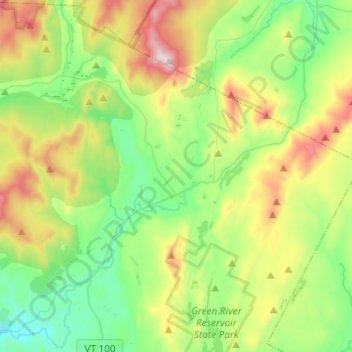
Name: Eden topographic map, elevation, terrain.
Location: Eden, Lamoille County, Vermont, United States (44.64214 -72.66139 44.79029 -72.41767)
Average elevation: 1,444 ft
Minimum elevation: 577 ft
Maximum elevation: 3,278 ft
Lamoille County trails, hiking, mountain biking, running and outdoor activities
Make a donation
Gear up for your next adventure:
As an Amazon Associate, this site earns from qualifying purchases at no extra cost to you.
Other topographic maps
Click on a map to view its topography, its elevation and its terrain.
Lamoille Union Lower Field North
United States > Vermont > Lamoille County > Hyde Park
Average elevation: 682 ft
Make a donation
Gear up for your next adventure:
As an Amazon Associate, this site earns from qualifying purchases at no extra cost to you.