
Lac-Ashuapmushuan topographic map
Interactive map
Click on the map to display elevation.
About this map
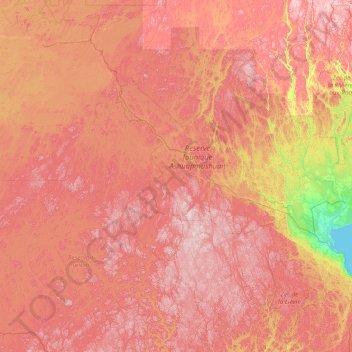
Name: Lac-Ashuapmushuan topographic map, elevation, terrain.
Average elevation: 1,362 ft
Minimum elevation: 315 ft
Maximum elevation: 2,375 ft
Other topographic maps
Click on a map to view its topography, its elevation and its terrain.
Poisson-Blanc
Canada > Quebec > Lac-Ashuapmushuan
Poisson-Blanc, Lac-Ashuapmushuan, Le Domaine-du-Roy, Saguenay–Lac-Saint-Jean, Quebec, Canada
Average elevation: 1,119 ft
Lac Paladru
Canada > Quebec > Lac-Ashuapmushuan
Lac Paladru, Route forestière 212, Lac-Ashuapmushuan, Le Domaine-du-Roy, Saguenay–Lac-Saint-Jean, Quebec, Canada
Average elevation: 1,473 ft
Lac Bourgeois
Canada > Quebec > Lac-Ashuapmushuan
Lac Bourgeois, Route forestière 212, Lac-Ashuapmushuan, Le Domaine-du-Roy, Saguenay–Lac-Saint-Jean, Quebec, Canada
Average elevation: 1,391 ft
Lac Fidèle
Canada > Quebec > Lac-Ashuapmushuan
Lac Fidèle, Chemin de la Consolidated, Lac-Ashuapmushuan, Le Domaine-du-Roy, Saguenay–Lac-Saint-Jean, Quebec, Canada
Average elevation: 1,726 ft
Lac Marteau
Canada > Quebec > Lac-Ashuapmushuan
Lac Marteau, Lac-Ashuapmushuan, Le Domaine-du-Roy, Saguenay - Lac-Saint-Jean, Quebec, Canada
Average elevation: 2,060 ft