
Dueñas topographic map
Click on the map to display elevation.
Dueñas
On March 8, 1820, with the support of 31 cabezas de barangay of the principalía of the visita of Dingle [formerly Baong], and the parish priest of Laglag, Fray Juan Raile, a petition for the re-elevation of Dingle into a pueblo was submitted to Miguel Calderón, alcalde mayor (equivalent to the present-day provincial governor) of Iloilo, through the leadership of the Dingleño teniente mayor (municipal vice-mayor) of Laglag, Don Juan Marcelino Dayot (Dingle gobernadorcillo, 1829–1835). On April 28, 1823, Dingle was thus re-elevated into a pueblo and separated itself from Laglag after almost two centuries of being under one pueblo.
About this map
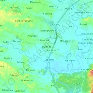
Name: Dueñas topographic map, elevation, terrain.
Location: Dueñas, Iloilo, Western Visayas, 5038, Philippines (11.02516 122.57827 11.10516 122.65827)
Average elevation: 164 ft
Minimum elevation: 75 ft
Maximum elevation: 541 ft
Other topographic maps
Click on a map to view its topography, its elevation and its terrain.
Panay
Panay island is the sixth largest island in the Philippines by area, with a total land area of 12,011 km2 (4,637 sq mi). Mount Madja-as is the highest point in Panay with an elevation of 2,117 metres (6,946 ft) above sea level, located in town of Culasi in the northern province of Antique. Central Panay…
Average elevation: 384 ft
Guimbal
Guimbal, a coastal municipality, is located at the south-western part of Iloilo province. It is situated between the coordinates of 1250 57’ longitude, and 100 39’ latitude. It is 29 kilometres (18 mi) from Iloilo City, and has a total land area of 4,461 hectares (11,020 acres). It is only six feet above…
Average elevation: 89 ft
Panay
Panay island is the sixth largest island in the Philippines by area, with a total land area of 12,011 km2 (4,637 sq mi). Mount Madja-as is the highest point in Panay with an elevation of 2,117 metres (6,946 ft) above sea level, located in town of Culasi in the northern province of Antique. Central Panay…
Average elevation: 384 ft
Guimbal
Guimbal, a coastal municipality, is located at the south-western part of Iloilo province. It is situated between the coordinates of 1250 57’ longitude, and 100 39’ latitude. It is 29 kilometres (18 mi) from Iloilo City, and has a total land area of 4,461 hectares (11,020 acres). It is only six feet above…
Average elevation: 89 ft