
Make a donation
Gear up for your next adventure:
As an Amazon Associate, this site earns from qualifying purchases at no extra cost to you.
Huanuni topographic map
Click on the map to display elevation.
Make a donation
Gear up for your next adventure:
As an Amazon Associate, this site earns from qualifying purchases at no extra cost to you.
Huanuni
Huanuni está situado a una altitud de 3.957 metros sobre el nivel del mar. En cuanto a distancia, Huanuni se encuentra a 45 km de Oruro y a 310 km de Potosí. La capital del municipio forma parte de la Ruta Nacional 6 de Bolivia.
Make a donation
Gear up for your next adventure:
As an Amazon Associate, this site earns from qualifying purchases at no extra cost to you.
About this map
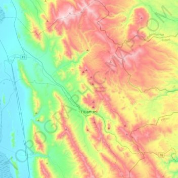
Name: Huanuni topographic map, elevation, terrain.
Location: Huanuni, Pantaleón Dalence, Oruro, 6500, Bolivia (-18.43328 -66.91167 -18.03749 -66.52826)
Average elevation: 13,593 ft
Minimum elevation: 12,110 ft
Maximum elevation: 15,850 ft
Make a donation
Gear up for your next adventure:
As an Amazon Associate, this site earns from qualifying purchases at no extra cost to you.
Other topographic maps
Click on a map to view its topography, its elevation and its terrain.