
Make a donation
Gear up for your next adventure:
As an Amazon Associate, this site earns from qualifying purchases at no extra cost to you.
Zwevezele topographic map
Click on the map to display elevation.
Make a donation
Gear up for your next adventure:
As an Amazon Associate, this site earns from qualifying purchases at no extra cost to you.
Zwevezele
Zwevezele ligt op de overgang van Zandig Vlaanderen (in het noorden) naar Zandlemig Vlaanderen (in het zuiden). De hoogte bedraagt 18-44 meter en het landschap is licht heuvelig. Een waterloop is de Jobeek welke in noordelijke richting stroomt. In het noorden vindt men de Munkebossen.
Make a donation
Gear up for your next adventure:
As an Amazon Associate, this site earns from qualifying purchases at no extra cost to you.
About this map
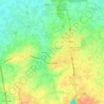
Name: Zwevezele topographic map, elevation, terrain.
Average elevation: 98 ft
Minimum elevation: 39 ft
Maximum elevation: 164 ft
Make a donation
Gear up for your next adventure:
As an Amazon Associate, this site earns from qualifying purchases at no extra cost to you.
Other topographic maps
Click on a map to view its topography, its elevation and its terrain.
Make a donation
Gear up for your next adventure:
As an Amazon Associate, this site earns from qualifying purchases at no extra cost to you.