Geolocate
👉 Easily get elevation data in JSON, GeoTIFF and KML formats using Elevation API
Thank you for supporting this site ❤️
Make a donation

Perez topographic map

Click on the map to display elevation.

About this map

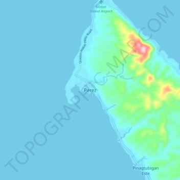
Name: Perez topographic map, elevation, terrain.

Location: Perez, Quezon, Calabarzon, Philippines (14.15351 121.88436 14.23351 121.96436)

Average elevation: 59 ft

Minimum elevation: 0 ft

Maximum elevation: 758 ft

Gear up for your next adventure:

🔦Compact Flashlight - Reliable flashlight for emergencies
🔌USB Car Charger - Car charger for on‑the‑go power needs
🎒Day Hiking Backpack - Lightweight backpack perfect for day trips and outdoor adventures
🔊Portable Camp Speaker - Music and alerts at camp
🖼️Topo Map Wall Art - Decorative topographic prints of famous peaks and regions

As an Amazon Associate, this site earns from qualifying purchases at no extra cost to you.