
Thank you for supporting this site ❤️
Make a donation
Make a donation
Gear up for your next adventure:
As an Amazon Associate, this site earns from qualifying purchases at no extra cost to you.
Lower Sichey topographic map
Click on the map to display elevation.
Thank you for supporting this site ❤️
Make a donation
Make a donation
Gear up for your next adventure:
As an Amazon Associate, this site earns from qualifying purchases at no extra cost to you.
About this map
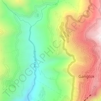
Name: Lower Sichey topographic map, elevation, terrain.
Location: Lower Sichey, Gangtok, East Sikkim District, Sikkim, India (27.32204 88.59363 27.35087 88.61253)
Average elevation: 4,436 ft
Minimum elevation: 3,209 ft
Maximum elevation: 6,056 ft
Thank you for supporting this site ❤️
Make a donation
Make a donation
Gear up for your next adventure:
As an Amazon Associate, this site earns from qualifying purchases at no extra cost to you.