Geolocate

La Junta topographic map

Click on the map to display elevation.

About this map

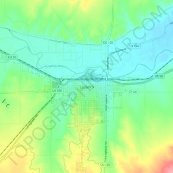
Name: La Junta topographic map, elevation, terrain.

Location: La Junta, Otero County, Colorado, 81050, United States (37.94501 -103.58383 38.02501 -103.50383)

Average elevation: 4,137 ft

Minimum elevation: 4,032 ft

Maximum elevation: 4,370 ft

Otero County trails, hiking, mountain biking, running and outdoor activities

Gear up for your next adventure:

🦺Reflective Outdoor Gear - Safety gear for low‑light conditions
🥾Women's Hiking Boots - Top-rated trail boots with ankle support and superior grip
👓Polarized Sunglasses - Outdoor sunglasses for glare reduction
📡Handheld GPS Device - Reliable handheld GPS for outdoor navigation
🔋Rechargeable Batteries - Power up your outdoor devices

As an Amazon Associate, this site earns from qualifying purchases at no extra cost to you.