Geolocate

Al Arish topographic map

Click on the map to display elevation.

About this map

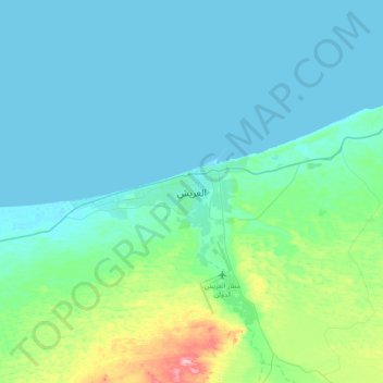
Name: Al Arish topographic map, elevation, terrain.

Location: Al Arish, North Sinai, Egypt (30.96725 33.64459 31.28725 33.96459)

Average elevation: 108 ft

Minimum elevation: -3 ft

Maximum elevation: 774 ft

Gear up for your next adventure:

🖼️Topo Map Wall Art - Decorative topographic prints of famous peaks and regions
🥤Water Filter Bottle - All‑in‑one filter bottle for safe hydration
🛰️Handheld GPS Units - Professional satellite navigators for precise backcountry mapping
🌎3D Topographic Globes - Raised relief globes for a tactile understanding of geography
🧭GPS Watch Accessories - Bands and chargers for GPS watches

As an Amazon Associate, this site earns from qualifying purchases at no extra cost to you.