Geolocate

Pansol topographic map

Click on the map to display elevation.

About this map

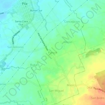
Name: Pansol topographic map, elevation, terrain.

Location: Pansol, Pila, Laguna, Calabarzon, 4010, Philippines (14.19606 121.35504 14.23606 121.39504)

Average elevation: 66 ft

Minimum elevation: 13 ft

Maximum elevation: 161 ft

Other topographic maps

Click on a map to view its topography, its elevation and its terrain.

Bulilan Norte

Philippines > Laguna > Pila

Average elevation: 26 ft

Concepcion

Philippines > Laguna > Pila

Average elevation: 52 ft

Labuin

Philippines > Laguna > Pila

Average elevation: 23 ft

Mojon

Philippines > Laguna > Pila

Average elevation: 62 ft

Gear up for your next adventure:

🛡️Insect Repellent - Protection against bugs during outdoor activities
🔌USB Car Charger - Car charger for on‑the‑go power needs
🛰️Handheld GPS Units - Professional satellite navigators for precise backcountry mapping
🧦Merino Wool Socks - Moisture-wicking, blister-preventing socks for long treks
🧭Pro Hiking Compasses - High-accuracy liquid-filled compasses for topographic orientation

As an Amazon Associate, this site earns from qualifying purchases at no extra cost to you.