
Ebermannstadt topographic map
Click on the map to display elevation.
Ebermannstadt
Die Stadt liegt im Freistaat Bayern, rund 35 km nördlich von Nürnberg und etwa 25 km südöstlich von Bamberg im Naturpark Fränkische Schweiz-Veldensteiner Forst im Tal der Wiesent auf einer Höhe von 292 bis 545 m ü. NHN. Durch ihre Lage nennt sich die Stadt selbst „das Herz der Fränkischen Schweiz“ und sieht sich als Eingangstor zur Fränkischen Schweiz. Bis 1972 war Ebermannstadt Sitz des gleichnamigen Landkreises.
About this map
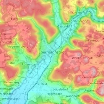
Name: Ebermannstadt topographic map, elevation, terrain.
Average elevation: 1,339 ft
Minimum elevation: 912 ft
Maximum elevation: 1,867 ft