
Thank you for supporting this site ❤️
Make a donation
Make a donation
Gear up for your next adventure:
As an Amazon Associate, this site earns from qualifying purchases at no extra cost to you.
Masciano topographic map
Click on the map to display elevation.
Thank you for supporting this site ❤️
Make a donation
Make a donation
Gear up for your next adventure:
As an Amazon Associate, this site earns from qualifying purchases at no extra cost to you.
About this map
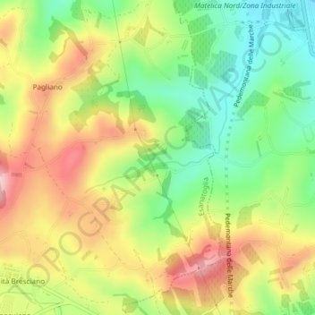
Name: Masciano topographic map, elevation, terrain.
Location: Masciano, Esanatoglia, Macerata, Marche, 62024, Italia (43.25326 12.96860 43.27326 12.98860)
Average elevation: 1,348 ft
Minimum elevation: 1,024 ft
Maximum elevation: 1,716 ft
Thank you for supporting this site ❤️
Make a donation
Make a donation
Gear up for your next adventure:
As an Amazon Associate, this site earns from qualifying purchases at no extra cost to you.