
Make a donation
Gear up for your next adventure:
As an Amazon Associate, this site earns from qualifying purchases at no extra cost to you.
Tielrode topographic map
Click on the map to display elevation.
Make a donation
Gear up for your next adventure:
As an Amazon Associate, this site earns from qualifying purchases at no extra cost to you.
Tielrode
Tielrode ligt nabij de samenvloeiing van Durme en Schelde. Ten noorden van de kom van Tielrode bevindt zich de Cuesta van het Waasland. De hoogte varieert van 2 meter bij de Durme tot 31 meter op de cuesta. Het 12ha grote provinciaal domein De Roomakker bevindt zich ten noorden van de kom van Tielrode. Ten zuiden van de kom ligt het Tielrodebroek.
Make a donation
Gear up for your next adventure:
As an Amazon Associate, this site earns from qualifying purchases at no extra cost to you.
About this map
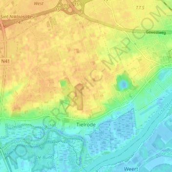
Name: Tielrode topographic map, elevation, terrain.
Average elevation: 52 ft
Minimum elevation: -13 ft
Maximum elevation: 102 ft
Make a donation
Gear up for your next adventure:
As an Amazon Associate, this site earns from qualifying purchases at no extra cost to you.