
Make a donation
Gear up for your next adventure:
As an Amazon Associate, this site earns from qualifying purchases at no extra cost to you.
Saladillo topographic map
Click on the map to display elevation.
Make a donation
Gear up for your next adventure:
As an Amazon Associate, this site earns from qualifying purchases at no extra cost to you.
About this map
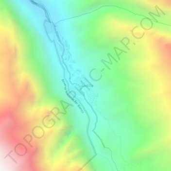
Name: Saladillo topographic map, elevation, terrain.
Average elevation: 7,070 ft
Minimum elevation: 4,984 ft
Maximum elevation: 10,486 ft
Make a donation
Gear up for your next adventure:
As an Amazon Associate, this site earns from qualifying purchases at no extra cost to you.
Other topographic maps
Click on a map to view its topography, its elevation and its terrain.
Laguna del Inca
Chile > Región de Valparaíso > Provincia de Los Andes > Los Andes > Portillo
Average elevation: 10,397 ft
Parque Andino Juncal
Chile > Región de Valparaíso > Provincia de Los Andes > Los Andes
Average elevation: 12,490 ft
rio blanco (aconcagua)
Chile > Región de Valparaíso > Provincia de Los Andes > Los Andes
Average elevation: 9,839 ft
Rio Blanco
Chile > Región de Valparaíso > Provincia de Los Andes > Los Andes > Saladillo
Average elevation: 6,946 ft
Make a donation
Gear up for your next adventure:
As an Amazon Associate, this site earns from qualifying purchases at no extra cost to you.