Geolocate

Andalo topographic map

Click on the map to display elevation.

Andalo

The town lies on the Paganella plateau, between the mountains Piz Galin, elevation 2,442 metres (8,012 ft), and Paganella, 2,125 metres (6,972 ft), and its territory is part of the Adamello-Brenta natural park.

About this map

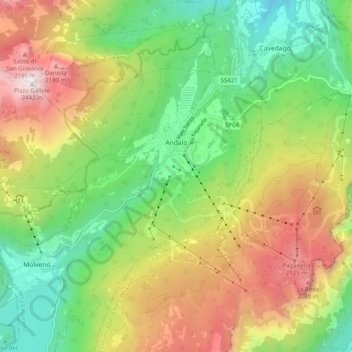
Name: Andalo topographic map, elevation, terrain.

Location: Andalo, Comunità della Paganella, Provincia di Trento, Trentino-Alto Adige/Südtirol, 38018, Italy (46.13811 10.92783 46.18070 11.02865)

Average elevation: 4,491 ft

Minimum elevation: 2,149 ft

Maximum elevation: 7,913 ft

Gear up for your next adventure:

🥇GPS Hiking Watch - Multi‑sport GPS watch with navigation and trail tracking
📶Vehicle Signal Boosters - Improve reception in rural areas while driving to trailheads
🪶Thermal Camp Blanket - Extra warmth for cold nights
🧭Map Reading Tools - Tools and kits for map navigation
🧢Sun Protection Hats - Wide-brimmed and UPF-rated hats for high-altitude sun safety

As an Amazon Associate, this site earns from qualifying purchases at no extra cost to you.