
Murphy topographic map
Click on the map to display elevation.
Murphy
Murphy is located in southwestern North Carolina, approximately halfway between Atlanta, Georgia and Knoxville, Tennessee. The topography sonsists of gentle rolling hills and mountains with tall peaks, including ranges from 1800 ft to more than 5000 ft elevation. The location in the Blue Ridge Mountains has helped the community retain a fairly rural character, surrounded by wildlife such as bear, deer, fox and recently reintroduced elk.
About this map
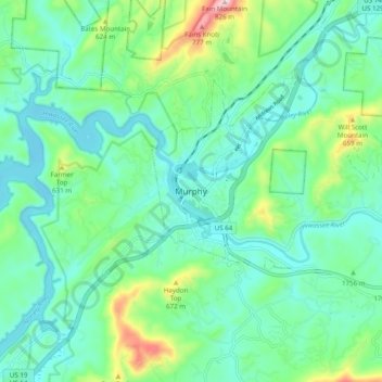
Name: Murphy topographic map, elevation, terrain.
Location: Murphy, Cherokee County, North Carolina, United States (35.04758 -84.07463 35.12758 -83.99463)
Average elevation: 1,732 ft
Minimum elevation: 1,460 ft
Maximum elevation: 2,641 ft
Cherokee County trails, hiking, mountain biking, running and outdoor activities