
Tunkhannock topographic map
Click on the map to display elevation.
About this map
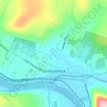
Name: Tunkhannock topographic map, elevation, terrain.
Average elevation: 764 ft
Minimum elevation: 577 ft
Maximum elevation: 1,362 ft
Wyoming County trails, hiking, mountain biking, running and outdoor activities
Other topographic maps
Click on a map to view its topography, its elevation and its terrain.
Lake Carey
United States > Pennsylvania > Wyoming County > Lemon Township > Lemon > Lake Carey
Average elevation: 1,060 ft
Center Moreland
United States > Pennsylvania > Wyoming County > Northmoreland Township
Average elevation: 1,227 ft
Lake Sheridan Hill
United States > Pennsylvania > Wyoming County > Nicholson Township
Average elevation: 1,109 ft
Bardwell
United States > Pennsylvania > Wyoming County > Tunkhannock Township
Average elevation: 974 ft
Blue Ridge Mountain
United States > Pennsylvania > Wyoming County > Meshoppen Township
Average elevation: 856 ft
Forkston
United States > Pennsylvania > Wyoming County > Forkston Township
Average elevation: 1,161 ft