Geolocate

Eatonton topographic map

Click on the map to display elevation.

About this map

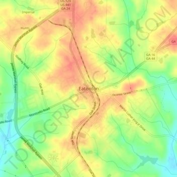
Name: Eatonton topographic map, elevation, terrain.

Location: Eatonton, Putnam County, Georgia, 31024, United States (33.30671 -83.40849 33.34671 -83.36849)

Average elevation: 525 ft

Minimum elevation: 413 ft

Maximum elevation: 610 ft

Putnam County trails, hiking, mountain biking, running and outdoor activities

Gear up for your next adventure:

🔦LED Headlamp - Bright and durable LED headlamp for night navigation
🦺Reflective Outdoor Gear - Safety gear for low‑light conditions
🪶Camp Gear Gift Set - Perfect gift bundle for outdoor fans
📷Action Camera - Capture your outdoor adventures in HD
🔋Rechargeable Batteries - Power up your outdoor devices

As an Amazon Associate, this site earns from qualifying purchases at no extra cost to you.