
Thank you for supporting this site ❤️
Make a donation
Make a donation
Gear up for your next adventure:
As an Amazon Associate, this site earns from qualifying purchases at no extra cost to you.
Lowood topographic map
Click on the map to display elevation.
Thank you for supporting this site ❤️
Make a donation
Make a donation
Gear up for your next adventure:
As an Amazon Associate, this site earns from qualifying purchases at no extra cost to you.
About this map
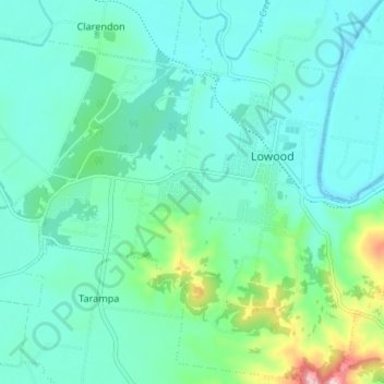
Name: Lowood topographic map, elevation, terrain.
Location: Lowood, Somerset Regional, Queensland, 4311, Australia (-27.50095 152.53621 -27.43604 152.60434)
Average elevation: 272 ft
Minimum elevation: 85 ft
Maximum elevation: 1,086 ft
Thank you for supporting this site ❤️
Make a donation
Make a donation
Gear up for your next adventure:
As an Amazon Associate, this site earns from qualifying purchases at no extra cost to you.