Geolocate

Plymouth topographic map

Click on the map to display elevation.

About this map

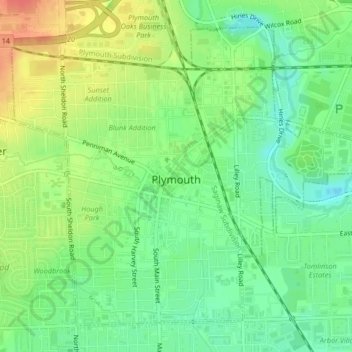
Name: Plymouth topographic map, elevation, terrain.

Location: Plymouth, Wayne County, Michigan, United States (42.35850 -83.48687 42.38445 -83.44552)

Average elevation: 732 ft

Minimum elevation: 659 ft

Maximum elevation: 833 ft

Wayne County trails, hiking, mountain biking, running and outdoor activities

Other topographic maps

Click on a map to view its topography, its elevation and its terrain.

Perrinville

United States > Michigan > Wayne County > Westland

Average elevation: 640 ft

Sunnyside

United States > Michigan > Wayne County > Romulus

Average elevation: 636 ft

Calvert Park

United States > Michigan > Wayne County > Detroit

Average elevation: 643 ft

Elm

United States > Michigan > Wayne County > Livonia

Average elevation: 640 ft

Newburg

United States > Michigan > Wayne County > Livonia

Average elevation: 686 ft

Dearborn

United States > Michigan > Wayne County > Dearborn

Average elevation: 623 ft

Gear up for your next adventure:

📚USA Hiking Guide Books - Top trail guides and map books
🎒Day Hiking Backpack - Lightweight backpack perfect for day trips and outdoor adventures
🪑Ultralight Camp Chairs - Portable seating for resting after a long day of mapping
Backpacking Tent - Lightweight and durable tent for multi‑day hikes
🔥Fast-Boil Camping Stoves - Efficient cooking systems for quick trail meals

As an Amazon Associate, this site earns from qualifying purchases at no extra cost to you.