
Thank you for supporting this site ❤️
Make a donation
Make a donation
Gear up for your next adventure:
As an Amazon Associate, this site earns from qualifying purchases at no extra cost to you.
Frigiliana topographic map
Click on the map to display elevation.
Thank you for supporting this site ❤️
Make a donation
Make a donation
Gear up for your next adventure:
As an Amazon Associate, this site earns from qualifying purchases at no extra cost to you.
About this map
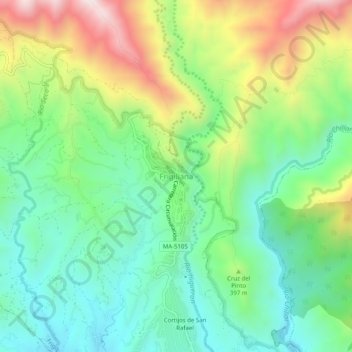
Name: Frigiliana topographic map, elevation, terrain.
Location: Frigiliana, La Axarquía, Malaga, Andalusia, 29788, Spain (36.77091 -3.91539 36.81091 -3.87539)
Average elevation: 1,076 ft
Minimum elevation: 243 ft
Maximum elevation: 2,648 ft
Thank you for supporting this site ❤️
Make a donation
Make a donation
Gear up for your next adventure:
As an Amazon Associate, this site earns from qualifying purchases at no extra cost to you.