
Make a donation
Gear up for your next adventure:
As an Amazon Associate, this site earns from qualifying purchases at no extra cost to you.
Oberneuland topographic map
Click on the map to display elevation.
Make a donation
Gear up for your next adventure:
As an Amazon Associate, this site earns from qualifying purchases at no extra cost to you.
Oberneuland
Die innerörtlichen Haupterschließungstraßen sind die Oberneulander Heerstraße, Rockwinkler Heerstraße, Rockwinkler Landstraße, Franz-Schütte-Allee und Oberneulander Landstraße. Die drei bisher existierenden höhengleichen Bahnübergänge wurden beziehungsweise werden derzeit durch Unterführungen ersetzt.
Make a donation
Gear up for your next adventure:
As an Amazon Associate, this site earns from qualifying purchases at no extra cost to you.
About this map
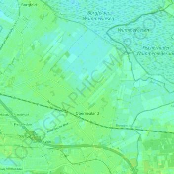
Name: Oberneuland topographic map, elevation, terrain.
Location: Oberneuland, Bremen-Ost, Bremen, 28355, Deutschland (53.07459 8.89583 53.12203 8.99083)
Average elevation: 16 ft
Minimum elevation: -3 ft
Maximum elevation: 30 ft
Make a donation
Gear up for your next adventure:
As an Amazon Associate, this site earns from qualifying purchases at no extra cost to you.
Other topographic maps
Click on a map to view its topography, its elevation and its terrain.
Make a donation
Gear up for your next adventure:
As an Amazon Associate, this site earns from qualifying purchases at no extra cost to you.