Geolocate

Rome topographic map

Click on the map to display elevation.

About this map

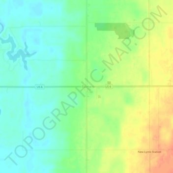
Name: Rome topographic map, elevation, terrain.

Location: Rome, Ashtabula County, Ohio, 44085, United States (41.58540 -80.88509 41.62540 -80.84509)

Average elevation: 846 ft

Minimum elevation: 784 ft

Maximum elevation: 932 ft

Ashtabula County trails, hiking, mountain biking, running and outdoor activities

Other topographic maps

Click on a map to view its topography, its elevation and its terrain.

Jefferson

United States > Ohio > Ashtabula County

Average elevation: 935 ft

Roaming Shores

United States > Ohio > Ashtabula County

Average elevation: 883 ft

Rock Creek

United States > Ohio > Ashtabula County

Average elevation: 814 ft

Edgewood

United States > Ohio > Ashtabula County

Average elevation: 702 ft

North Kingsville

United States > Ohio > Ashtabula County

Average elevation: 650 ft

New Lyme Township

United States > Ohio > Ashtabula County

Average elevation: 994 ft

Ashtabula

United States > Ohio > Ashtabula County

Average elevation: 656 ft

Conneaut

United States > Ohio > Ashtabula County

Average elevation: 696 ft

Geneva

United States > Ohio > Ashtabula County

Average elevation: 591 ft

Gear up for your next adventure:

🥾Hiking Shoes - Durable and comfortable shoes for trail hiking
🔥Camping Stove - Portable stove for camping and backcountry cooking
🧣Hiking Neck Gaiter - Multi‑use neck protection for outdoor weather
🔭Telescopic Hiking Pole - Adjustable pole for hiking stability
🧴Hand Sanitizer - Keep hands clean while hiking

As an Amazon Associate, this site earns from qualifying purchases at no extra cost to you.